ArcMap Examples

Below are examples of Geospatial Maps I created in ArcMap10 from ESRI Geographic Information Services (GIS) software. They demonstrate use of a wide variety of techniques and applications including spatial analysis, 3D analysis, land use, demographics, geocoding, georeferencing, and others. The maps are arranged in order from small scale (Municipal & Park), medium scale area (County) to large scale area (State, National and International) to demonstrate facility with a variety of type and kind of data based maps*.

Below the maps are Adobe .pdf versions for user friendly display and download. I used Adobe Photoshop to configure these maps from .mxd's to .jpg's and for easy web use.

*Note that this page is permanently "in progress" as I develop new versions of maps, or new maps altogether.

Fort Hunter in Dauphin County is an historic site of one of the earliest settled parts of Pennsylvania. Our team was tasked with using Trimble GPS (Geo-Positioning Systems) handheld devices to locate and outline each existing building, then build a location map from that data.

forthunterhamilton.pdf 
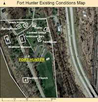
forthunterhamilton.pdf
Size : 1712.923 Kb
Type : pdf

This map of Harrisburg, PA shows geocoded locations of Historic Harrisburg Association 2011 preservation priorities,  contacts and donors. It is a clear visual presentation useful for marketing purposes by the organization.

HHA010512.pdf 
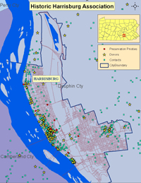
HHA010512.pdf
Size : 4888.022 Kb
Type : pdf

This map of Dauphin County, PA shows the townships and municipality borders.


Dauphin County PA Townships
Dauphin County PA Comprehensive Plan Map.pdf 
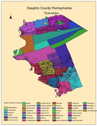
Dauphin County PA Comprehensive Plan Map.pdf
Size : 308.122 Kb
Type : pdf

This is a a map of Pennsylvania which shows the physical land features (physiography).


This is an example of laying in land use features. In this case, State Game lands.

PennsylvaniaStateGameLands.pdf 
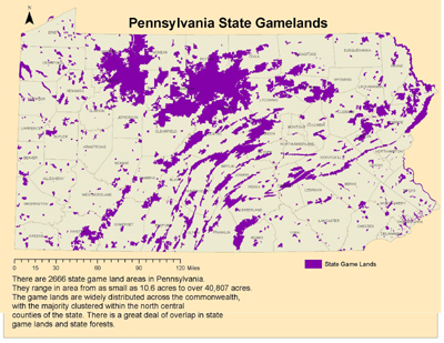
PennsylvaniaStateGameLands.pdf
Size : 940.467 Kb
Type : pdf

I created this map for a job interview with a conservation organization to show the rivers, lakes and streams in a specific area in Pennsylvania.


Clarion Rivers.pdf 
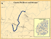
Clarion Rivers.pdf
Size : 388.22 Kb
Type : pdf

The map below shows new housing as of 2011 in Silver Spring Township, Cumberland County PA. I developed it as a consultant for Brad Furey Consulting, LLC as part of a demographic study we did for the Cumberland Valley School District to help determine enrollment trends over the next 5 years.

SilverSpringNEWHOUSING121311A.pdf 
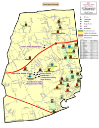
SilverSpringNEWHOUSING121311A.pdf
Size : 2535.3 Kb
Type : pdf

This is an example of a zoning map, useful for determining what types of residences, businesses and agriculture can be built in each municipal zone.


Dauphin County Zoning
Dauphin County PA Zoning.pdf 
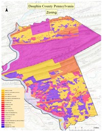
Dauphin County PA Zoning.pdf
Size : 1564.417 Kb
Type : pdf

...and this map of Pennsylvania shows the ratio of farming by county in Pennsylvania.


...and this is a map of land use across the commonwealth.

PennsylvaniaLanduse.pdf PennsylvaniaLanduse.pdf
Size : 2074.312 Kb
Type : pdf

Make a free website with Yola