The Laboratory

Below are projects I enjoy tinkering with...


This is a Prezi.com presentation on the History of Cartography http://prezi.com/22hdt_d1yygm/history-of-cartography/

Below are two three dimensional maps I developed for a report on the geological hazards in Pennsylvania. The top one is a mosaic draped overlay of a landslide into the Susquehanna river in Luzerne County in northeast PA. The second drapes a DEM (Digital Elevation Model) mosaic aerial photograph over the same landscape. The full report is below the maps in .pdf format.

Pennsylvania Geology Handbook.pdf Pennsylvania Geology Handbook.pdf
Size : 1696.107 Kb
Type : pdf

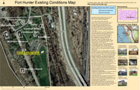
This is an example of an Existing Conditions project is for the national historical registry application for Fort Hunter in Dauphin County, PA . To create it we used Trimble GPS units to georeference each of the buildings in the park, then imported those polygonal coordinates into ArcMap as shapefiles and overlaid them on aerial maps. The finished product includes background text, pictures of the buildings and scale reference maps.

Fort Hunter GPS Project
forthunterhamilton1.pdf forthunterhamilton1.pdf
Size : 1712.922 Kb
Type : pdf

Following the March 11th, 2011 8.9 earthquake and consequent tsunami off the coast of the Sendai region of Japan, our remote sensing group was tasked with using live data to build maps detailing the evolving emergency the areas affected and the nuclear power plant crisis. My part of the project included creating the website and emergency preparedness section. The website is https://sites.google.com/site/japanearthquake031111/

Japanearthquakeer.pdf Japanearthquakeer.pdf
Size : 1120.621 Kb
Type : pdf

This topographic map shows the prefectures that were most directly impacted by the earthquake and tsunami. Note the location of the Fukushima Daiishi Nuclear Power Plant.

Make a free website with Yola